Crop health monitoring with drones enables farmers to detect nutrient deficiencies, pests, and water stress early, saving time and improving yield. On a 500-acre cornfield in Iowa, UAV monitoring with DJI Phantom 5 RTK reduced chemical application by 12% and detected early nitrogen deficiency in 18% of the field, preventing potential yield loss.
What Is Crop Health Monitoring with Drones
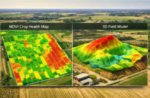
Crop health monitoring with drones involves aerial platforms equipped with multispectral, thermal, and RGB sensors to assess plant vigor and detect anomalies. UAVs fly programmed paths, capturing high-resolution images that map NDVI (Normalized Difference Vegetation Index) and other crop indicators. For example, DJI Phantom 5 RTK at 120 meters altitude achieves a 2.5 cm/pixel GSD, sufficient to identify stressed corn leaves before visual symptoms appear.GSD=Sensor Width×Flight HeightFocal Length×Image Width
This formula ensures precise mapping for actionable crop health analysis.
Why Farms Are Adopting Drone Technology
Drones reduce labor, increase precision, and allow early intervention for crop issues. On a 250-acre soybean farm in Kansas, UAV-based monitoring decreased herbicide overlap by 15%, reducing chemical costs by $450 per season.
| Method | Coverage | Labor Hours | Cost per Acre |
|---|---|---|---|
| Ground Scouting | 100 acres | 6 | $18 |
| Satellite Imagery | 500 acres | 1 | $9 |
| UAV Crop Monitoring | 400 acres | 1 | $7 |
Early detection of disease, drought stress, or pest infestation enables targeted interventions that improve yield and resource efficiency.
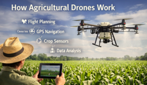
How Crop Health Monitoring with Drones Works Step by Step
- Pre-Flight Mapping
Upload field boundaries to drone software. If the field exceeds 600 acres, divide into multiple zones to optimize battery use. - Sensor Calibration
Calibrate multispectral and thermal sensors. If sunlight varies above 8000 lux, adjust exposure to maintain consistent NDVI readings. - Flight Execution
Fly UAV in grid pattern at 100–120 meters altitude. If wind exceeds 18 mph, postpone to avoid drift and blurred imaging. - Data Capture
Capture images with 75% forward and 65% side overlap. Enable RTK corrections for positional accuracy ±2 cm if GPS drift is detected. - Data Processing
Process images using Pix4D or DroneDeploy. Generate NDVI, disease, and water stress maps. Identify areas requiring fertilizer, irrigation, or pesticide intervention. - Reporting and Action
Provide field maps with recommendations. Highlight zones needing attention. Recommend variable-rate fertilizer application based on NDVI analysis.
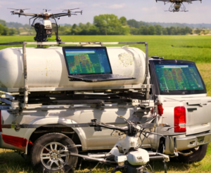
Equipment Used for This Service
| Device | Role | Key Specification |
|---|---|---|
| DJI Phantom 5 RTK | Multispectral imaging | 2.5 cm/pixel GSD, RTK-enabled |
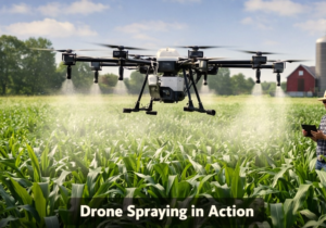
| DJI Agras T50 | Precision spraying | 50 L payload, VRA support |
| Lithium-Silicon Batteries | Extended flight time | 35–40 min per flight |
| RTK Base Station | GPS precision | ±2 cm horizontal |
| DroneDeploy / Pix4D | Data analysis | Cloud-based NDVI and crop mapping |
High-resolution imagery integrated with farm management software ensures actionable insights from aerial surveys.
Real Farm Use Case
On a 500-acre corn farm in Iowa, UAV crop health monitoring with Phantom 5 RTK and thermal sensors achieved:
- Field coverage: 500 acres in 3 flights
- Labor saved: 50 hours per month
- Identified deficiencies: Nitrogen stress in 18% of the field
- ROI: $3,000 saved in fertilizer and labor
The multispectral NDVI analysis enabled variable-rate fertilizer application, reducing chemical overlap by 12% and improving yield by 6 bushels per acre.
Pros and Cons of Crop Health Monitoring with Drones
| Pros | Cons |
|---|---|
| Early detection of stress and disease | Initial investment $6,500–$15,000 |
| Reduces labor and manual scouting | Requires trained UAV operators |
| Enables variable-rate chemical application | Weather-dependent flights |
| Integrates with precision agriculture software | FAA Part 107 certification required |
Common Challenges and Solutions
| Challenge | Solution | Field-Proven Result |
|---|---|---|
| Poor GPS accuracy | Use RTK-enabled UAVs | ±2 cm horizontal accuracy |
| Weather interruptions | Monitor wind and light conditions | Ensure clear imaging under <18 mph wind |
| Data overload | Automate NDVI and multispectral analysis | Reduce processing time from 5 hours to 1 hour per 500-acre zone |
Future of Drone Farming Technology
By 2026, crop monitoring drones will include AI-powered early disease detection, BVLOS flight for large-scale operations, and batteries exceeding 50 minutes endurance. Integration with automated irrigation and spraying systems will create fully data-driven crop management. NDVI, thermal imaging, and multispectral analysis will become standard practice for high-value crops.
Finding Reliable Drone Service Providers
- Verify FAA Part 107 certification and any BVLOS Waivers.
- Confirm experience with multispectral, NDVI, and thermal imaging for crops.
- Request sample reports from farms of similar crop type and acreage.
- Ensure integration with your precision agriculture software, including variable-rate fertilizer or pesticide management.
Certified providers maximize crop health insights while ensuring regulatory compliance and ROI.
FAQ Section
1. How much does drone crop monitoring cost?
Costs range from $6–$8 per acre, depending on field size, sensors, and processing needs.
2. How quickly can a UAV survey crops?
A 500-acre cornfield can be covered in 3 flights totaling ~4 hours, with post-processing in 2 hours.
3. Can drones detect crop diseases early?
Yes. NDVI and thermal imaging detect stress, disease, and water deficiency 1–2 weeks before visual symptoms appear.
4. Is FAA certification necessary?
Yes. UAV operators must hold Part 107 certification, and BVLOS flights require proper Waivers.
5. Will drones replace traditional scouting?
Not entirely. Drones complement human scouting, providing faster, more precise data and reducing manual labor.