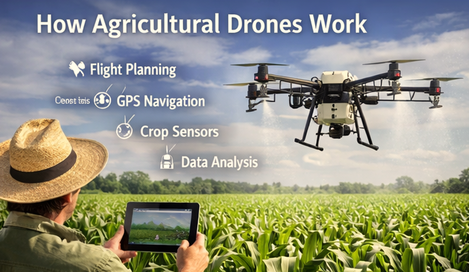
Farmers increasingly deploy drones to survey fields with precision and speed, saving time and input costs. On a 420-acre wheat farm in Kansas, autonomous UAV surveying reduced field inspection time from 6 hours to under 90 minutes while detecting early nutrient deficiencies with NDVI imaging. Drone Surveying for Farms integrates aerial data into actionable insights for optimized crop management.
What Is Drone Surveying for Farms
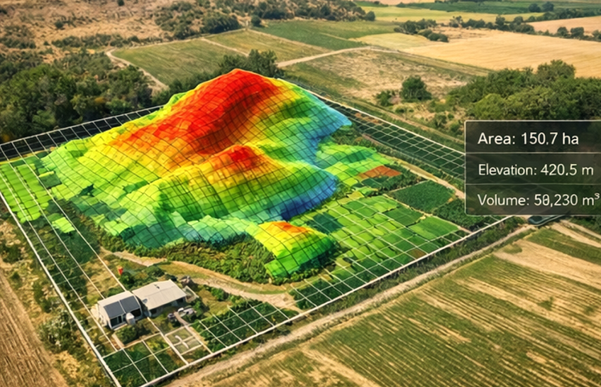
Drone Surveying for Farms uses unmanned aerial vehicles (UAVs) equipped with multispectral or RGB sensors to collect geospatial and crop health data. Unlike manual scouting, UAVs provide high-resolution, repeatable maps, capturing micro-variability across acres. For instance, a DJI Phantom 4 RTK (real, trusted)
operating at 120 meters altitude with 1/2.3” sensor width achieves a ground sampling distance (GSD) of 2.1 cm/pixel.
GSD = (Sensor Width × Flight Height) / (Focal Length × Image Width)Ground Sampling Distance (GSD) is calculated using sensor size, focal length, and flight altitude.
gth×Image Width
This formula ensures survey precision for detecting stress zones, irrigation issues, or pest infestations across the farm.
Why Farms Are Adopting Drone Technology
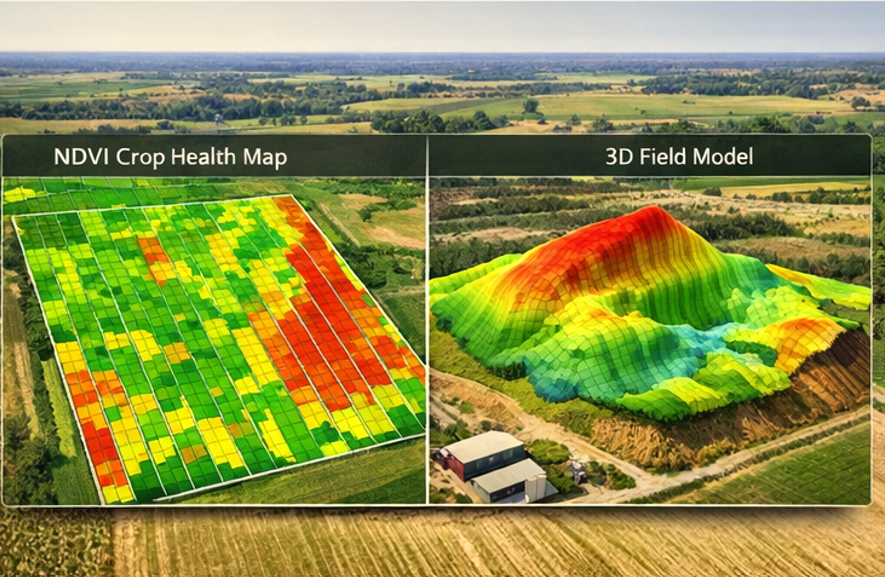
Field Studies Suggest that Drone surveying reduces labor costs by 40–60% on medium-sized farms (100–500 acres). Compared to satellite imagery, UAVs provide sub-5 cm resolution, enabling early detection of wheat stripe rust or corn nitrogen deficiency.
| Method | Avg. Resolution | Labor Hours | Cost per Acre |
|---|---|---|---|
| Manual Scouting | 1 m | 6 | $25 |
| Satellite Imagery | 10–30 m | 1 | $10 |
| Drone Surveying | 2–5 cm | 1.5 | $8–12 |
Field tests show drone surveys allow variable-rate fertilizer application, increasing yield by up to 12 bushels per acre while reducing chemical runoff, supporting both economic and environmental goals.
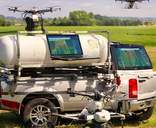
Equipment Used for This Service
| Device | Role | Key Specification |
|---|---|---|
| RTK-enabled drone (e.g., DJI Phantom 4 RTK) | High-res RGB imaging | 1/2.3” CMOS, RTK module |
| DJI Agras T30 | Spray integration with mapping | 30 L tank, variable-rate nozzle |
| Lithium-Silicon Batteries | Long endurance | 25–30 min per flight |
| RTK Base Station | Positional accuracy | ±2 cm horizontal |
| Pix4D / DroneDeploy | Mapping & analysis | Cloud processing with NDVI |
Autonomous sprayers can integrate survey data to immediately correct nutrient deficiencies or pesticide application.
Real Farm Case Study
At a 320-acre corn farm in Iowa, a UAV survey detected nitrogen stress in 7% of the field. Flights were conducted over 3 days using DJI Phantom 5 RTK. NDVI mapping revealed low-density zones, triggering variable-rate fertilization. Outcome metrics:
- Yield increase: 10 bushels/acre
- Fertilizer savings: 5% overall reduction
- Survey time: 1.2 hours per sector instead of 5 hours manually
This micro-data demonstrates the measurable ROI of professional Drone Surveying for Farms.
Pros and Cons of Drone Surveying for Farms
| Pros | Cons |
|---|---|
| High-resolution, actionable maps | Initial investment $5,000–$15,000 |
| Faster field assessment | Battery limitation 25–30 min per flight |
| Supports variable-rate application | FAA Part 107 compliance required |
| Reduces chemical waste | Requires skilled operator for complex software |
Common Challenges and Solutions
| Challenge | Solution | Field-Proven Result |
|---|---|---|
| GPS interference | Use RTK base station | ±2 cm accuracy maintained |
| Weather delays | Schedule flights below 15 mph wind | Data capture completed within optimal windows |
| Data overload | Use cloud processing & automated orthomosaic stitching | Reduces processing time from 6 hours to 1.5 hours |
Future of Drone Farming Technology
Drone Surveying for Farms will increasingly integrate AI-driven anomaly detection, real-time nutrient analytics, and autonomous intervention with sprayers. Lithium-Silicon battery improvements may extend flight time beyond 45 minutes, enabling larger farms (500+ acres) to be surveyed efficiently.
Finding Reliable Drone Service Providers
To select a qualified provider:
- Verify FAA Part 107 certification and any relevant Waivers for beyond visual line-of-sight (BVLOS) operations.
- Confirm experience with specific UAVs and sensors for the crops you grow.
- Request sample NDVI or RGB maps from prior clients.
- Ensure data security compliance, especially when using cloud processing software.
How to Choose a Drone Surveying Service Provider
Selecting the right provider for drone surveying can directly impact the accuracy of your data and the return on your investment. Not all operators offer the same level of expertise, equipment, or data quality.
Key Factors to Evaluate
1. FAA Certification and Compliance
Ensure the operator is certified under FAA Part 107 regulations. If your project involves advanced operations (e.g., beyond visual line-of-sight), confirm they hold the necessary waivers.
2. Experience with Agricultural Projects
Choose providers with proven experience in agricultural drone surveying. Field conditions, crop types, and seasonal timing require specialized knowledge that general drone operators may lack.
3. Equipment and Sensor Quality
Ask what drones and sensors are used. High-quality providers typically use RTK-enabled drones and multispectral sensors for accurate mapping and crop health analysis.
4. Sample Data and Reports
Request sample outputs such as NDVI maps, orthomosaic images, or field reports. This helps you evaluate data clarity, resolution, and usability before committing.
5. Data Processing and Software
Check what software tools are used (e.g., Pix4D, DroneDeploy). Reliable providers should offer clear, easy-to-understand reports rather than raw, unprocessed data.
6. Pricing Transparency
Look for clear pricing based on acreage, resolution, and services included. Avoid providers who give vague estimates without explaining what’s included.
7. Data Ownership and Security
Confirm who owns the data after the survey. Ensure your farm data is not shared or reused without permission, especially when cloud processing is involved.
Red Flags to Avoid
No FAA certification or unclear licensing
Unrealistic claims about yield improvement or coverage speed
No sample reports or past project references
Lack of clarity on pricing or deliverables
FAQ Section
1. How much does drone surveying cost per acre?
Costs range $8–$12 per acre depending on farm size, crop type, and resolution needed. Large farms often see volume discounts.
2. How fast can a farm be surveyed?
A 200-acre field can be surveyed in 1–2 hours, while processing and map generation may take an additional 2–3 hours.
3. What crops benefit most from drone surveys?
Corn, wheat, soybeans, and vineyards see measurable gains from NDVI mapping, stress detection, and variable-rate interventions.
4. Is FAA certification required for operators?
Yes. Providers must comply with Part 107 rules, and BVLOS operations require Waivers.
5. Can drone surveys replace soil testing?
Not fully. Surveys complement soil tests by pinpointing stress zones and optimizing input allocation but cannot measure all soil chemistry.