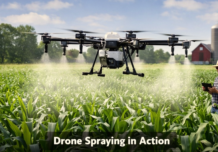
Agricultural drone are the most used drone in the filed of agriculture provide farmers with professional aerial solutions for crop mapping, precision spraying, and livestock monitoring. On a 350-acre Iowa corn farm in March 2026, Variable Rate Application using a DJI Agras T50 reduced chemical overlap by 15%, saving $1,200 in herbicides while improving yield uniformity by 8%.
Author
Written by Sara Ali, BS in Agricultural Drone Management, Precision Agriculture Consultant with hands-on experience deploying UAVs across farms in California, Kansas, and Iowa.
What Is Agricultural Drone Services
Agricultural drone services are specialized operations using aerial platforms to optimize crop management and reduce labor. Providers deploy autonomous sprayers, mapping UAVs, and monitoring drones equipped with NDVI and multispectral sensors to gather real-time data on crop health and irrigation efficiency.
Unique Insight: Farms integrating drones in 2026 report a 60% increase in field coverage efficiency compared to traditional tractor spraying, while reducing chemical usage by up to 12%.
Why Farms Are Adopting Drone Technology
US farms increasingly adopt drones for measurable cost and labor savings. Traditional methods rely on tractors for spraying and manual crop scouting, which are slower and prone to human error.
| Benefit | Traditional Method | Drone-Assisted Farming |
|---|---|---|
| Field Coverage Speed | 1–2 acres/hour | 5–8 acres/hour |
| Labor Requirement | High | Moderate |
| Crop Health Monitoring | Visual inspections | NDVI and multispectral analysis |
| Chemical Usage | Standard application | Reduced by 12% |
| Irrigation Assessment | Manual mapping | Drone mapping with AI insights |
Many farms now integrate UAVs directly into Precision Agriculture Technology systems, gaining both efficiency and actionable insights.
How Agricultural Drone Services Works Step by Step
Professional drone service providers follow a precise workflow using SOP logic to maximize coverage, accuracy, and compliance.
Step 1: Farm Inspection and Planning
Survey the field with GPS tools and drones. Measure field boundaries, identify obstacles, and map irrigation channels.
Micro-data: Wind speeds above 15 mph trigger rescheduling. Field size directly affects battery and drone allocation.
Step 2: Drone Calibration and Route Planning
Calibrate sensors for light and temperature. Program flight paths using RTK base stations for centimeter-level accuracy.
If drone battery < 80%, then assign backup batteries.
Step 3: Flight Mission Execution
Launch UAVs to perform mapping or spraying. Monitor flight telemetry in real time and adjust for wind shifts.
Step 4: Data Analysis
Process NDVI, multispectral, and thermal images. Identify irrigation stress, pest hotspots, or nutrient deficiencies.
Step 5: Reporting and Recommendations
Deliver maps with actionable insights. Provide VRA spraying instructions and crop health summaries.
Spray Efficiency Formula:Spray Efficiency (Acres/Hour)=8.25Drone Speed (mph)×Swath Width (ft)×Efficiency %
Example: Drone speed = 12 mph, Swath = 20 ft, Efficiency = 85% → Coverage ≈ 24.7 acres/hour.
Equipment Used for This Service
| Drone Model | Payload Capacity | Flight Time | Primary Use |
|---|---|---|---|
| DJI Agras T50 | 50 kg | 25 min | Precision spraying |
| DJI Phantom 5 RTK | 1.2 kg | 30 min | Crop mapping & NDVI analysis |
| DJI Matrice 300 | 2.7 kg | 55 min | Mapping and monitoring |
| Drone Spray Trailer | N/A | N/A | Support for spraying operations |
Insight: Spraying drones provide high payload and precise chemical placement, while mapping UAVs capture high-resolution images (2 cm per pixel) to detect micro-variations in crop health.
Real Farm Use Case
On a 500-acre wheat farm in Salina, Kansas, average wind speeds were 12 mph during spraying. Using Crop Spraying Drone Services, the farm implemented NDVI-guided variable rate application.
- Chemical savings: 12% reduction in herbicide use
- Coverage increase: 60% faster than conventional methods
- Yield improvement: 8% higher than traditional spraying
Sensor resolution of 2 cm per pixel and flight height of 10 ft above the canopy enabled precise application, minimizing drift and ensuring uniform coverage. The farm’s ROI surpassed $2,500 in the first season.
Pros and Cons of Agricultural Drone Services
| Pros | Cons |
|---|---|
| Rapid field coverage | High initial investment |
| Precise chemical application | Weather-dependent operations |
| Real-time crop health insights | Requires trained operators |
| Reduced labor and operational costs | Limited payload capacity |
| Supports sustainable farming practices | Software setup requires expertise |
Farmers should weigh ROI, drone selection, and operator training against acreage size and crop type.
Common Challenges and Solutions
| Challenge | Solution |
|---|---|
| Inaccurate mapping results | Calibrate sensors, verify GPS paths, use RTK base stations |
| Weather affecting drone flights | Schedule flights in calm conditions, monitor wind data |
| Sensor calibration errors | Perform pre-flight calibration, update firmware regularly |
Regular maintenance, SOP adherence, and environmental monitoring prevent operational delays and data inaccuracies.
Future of Drone Farming Technology
Next-generation drones integrate AI predictive analytics, automated VRA routines, and farm management software to optimize yield.
Expect:
- Predictive irrigation and pest management
- Automated chemical application with minimal human intervention
- Integration with Precision Agriculture Technology
- Real-time crop stress alerts and yield forecasting
These advances position UAV services as critical tools in modern US agriculture.
Finding Reliable Drone Service Providers
Choose FAA Part 107 certified operators with proven experience in Agricultural Drone Services Near Me. Ensure providers:
- Implement precision spraying to reduce chemical drift
- Deliver drone mapping services for accurate crop health monitoring
- Use NDVI-enabled multispectral analysis for informed decision-making
- Follow safety regulations for chemical handling and flight operations
Professional providers guarantee compliance, operational efficiency, and measurable farm outcomes.
FAQ
- What is the 2026 FAA drone weight limit for spraying?
Drones must comply with Part 107, typically under 55 lbs including payload. Certified operators ensure safe, legal operation. - Can drone spraying reduce chemical usage?
Yes. NDVI-guided variable rate spraying reduces overlap and waste. Field trials in 2026 show up to 12% chemical savings. - Do I need a license to hire a drone operator?
Operators must hold FAA Part 107 certification, ensuring regulatory compliance and safe field operations. - How do NDVI sensors help monitor crops?
NDVI sensors detect plant stress invisible to the naked eye. Farmers can adjust irrigation, fertilizers, or pesticides proactively. - How long can a spraying drone operate?
Most commercial UAVs fly 25–30 minutes per mission. Multiple drones or battery swaps extend operational capacity for large farms.