Not sure which agricultural drone services are right for your farm, or what to expect when you hire a provider? You’re in the right place. Before you dive in, if you’re completely new to the technology, our complete beginner guide to what agricultural drones are and how they work covers every drone category, cost, and capability in plain language — a useful foundation before evaluating specific services.
Agricultural drone services are professional, FAA-compliant aerial operations designed to help US farmers manage crops and livestock more efficiently. Whether you need variable-rate spraying across 500 acres of wheat, NDVI-based crop health mapping, or thermal livestock tracking, there is a certified service provider equipped to deliver it.
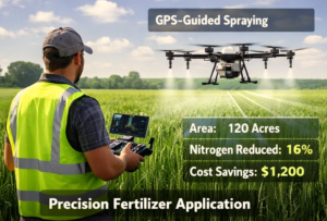
On a 350-acre Iowa corn farm in March 2026, variable rate application using a DJI Agras T50 reduced chemical overlap by 15%, saving $1,200 in herbicides while improving yield uniformity by 8%. That result repeatable across hundreds of US farms is why professional drone services are replacing traditional tractor spraying and manual scouting at scale.
This guide covers every major service type, how each one works step by step, what it costs, how to compare providers, and what to expect from your first mission.
| 60% Faster field coverage vs tractor spraying | 12% Average chemical reduction with NDVI guidance | $2,500+ Average first-season ROI on a 500-acre farm |
What Are Agricultural Drone Services?
Agricultural drone services are specialized commercial operations in which FAA Part 107 certified operators deploy autonomous UAVs — unmanned aerial vehicles — to perform precision farming tasks that traditional equipment cannot match for speed, accuracy, or terrain access.
Providers deploy three main types of aerial systems:
- Autonomous sprayers (such as the DJI Agras T50) — for variable-rate chemical application
- Mapping UAVs (such as the DJI Phantom 5 RTK) — for photogrammetric field mapping and NDVI analysis
- Monitoring drones (thermal and multispectral equipped) — for crop health and livestock tracking
Farms integrating professional drone services in 2026 report a 60% increase in field coverage efficiency compared to traditional tractor spraying, while reducing chemical usage by up to 12% through NDVI-guided variable rate application.
| How NDVI guidance works — read next Crop Health Monitoring with Drones: NDVI, Detection & Farm Insights |
Types of Agricultural Drone Services Available in 2026
The term ‘agricultural drone services’ covers five distinct service categories. Each serves a different farm need, uses different equipment, and is priced differently per acre.
1. Crop Spraying Services
Drone crop spraying uses heavy-lift UAVs equipped with smart nozzles and variable-rate technology to apply pesticides, herbicides, and fertilizers with centimeter-level precision. Unlike tractor spraying, drones can access wet fields, steep terrain, and orchard rows without soil compaction.
The Kansas wheat farm case study in the section below shows a 12% herbicide reduction and $2,500 ROI in a single season. For a full breakdown of how these savings work across different crop types, see our guide to crop spraying drone services — costs, benefits, and how they work.
2. Crop Mapping & NDVI Monitoring Services
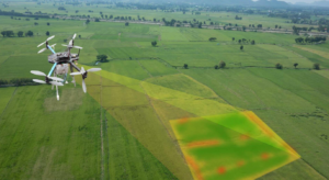
Mapping providers fly multispectral UAVs in precise grid patterns to generate orthomosaic maps, NDVI (Normalized Difference Vegetation Index) heat maps, and elevation models of your entire farm.
These maps reveal plant stress, irrigation failure, pest hotspots, and soil variability — often weeks before visible damage appears. Our guide explains exactly how NDVI maps from aerial imaging are read and acted on, including what each index value means and how variable-rate fertilizer decisions are made from the data.
3. Drone Mapping & Surveying Services
Drone mapping services produce detailed spatial data products — orthomosaic photos, 3D field models, contour maps, and drainage analysis. Farmers use these for irrigation planning, drainage design, and yield prediction. Our step-by-step guide covers how drone mapping works for farms from pre-flight through to final map delivery.
4. Aerial Farm Imaging Services
Aerial imaging providers capture high-resolution RGB and multispectral imagery across your entire farm, then deliver processed reports and field maps. This service is often combined with NDVI analysis for crop health reporting. Learn what providers actually deliver in our guide to aerial farm imaging services and drone crop analysis.
5. Livestock Monitoring Services
Thermal and RGB drone monitoring allows ranchers to track herd location, identify sick animals, and count livestock across large pastures in under an hour — work that previously took a full day on horseback. See how livestock monitoring drone services help US ranchers track animals from the air.
Why US Farms Are Adopting Drone Services in 2026
Traditional farming relies on tractors for spraying and manual scouting for crop health — methods that are slow, input-heavy, and limited by operator visibility. Professional drone services address every one of those limitations simultaneously.
| Task | Traditional Method | Drone Service | Improvement |
| Field Coverage Speed | 1–2 acres/hour | 5–8 acres/hour | 4–5× faster |
| Labor Requirement | High (3–4 operators) | Low (1 certified operator) | 60–75% reduction |
| Crop Health Monitoring | Visual inspections | NDVI + multispectral imaging | Detects stress 3–4 weeks earlier |
| Chemical Application | Standard broadcast rate | Variable rate — field by field | 10–15% reduction in usage |
| Irrigation Assessment | Manual field walking | AI-guided drone mapping | Same-day actionable data |
| Terrain Access | Limited (wet / steep fields) | Full access in all conditions | No compaction, no access limits |
Many farms now integrate UAV services directly into Precision Agriculture Technology systems, connecting drone data to farm management software so irrigation, fertiliser, and yield decisions are informed by real field data rather than estimates.
How Agricultural Drone Services Work: Step-by-Step
Professional providers follow a structured five-step SOP (Standard Operating Procedure) to maximise coverage accuracy, data quality, and regulatory compliance on every mission.
Step 1: Farm Inspection and Mission Planning
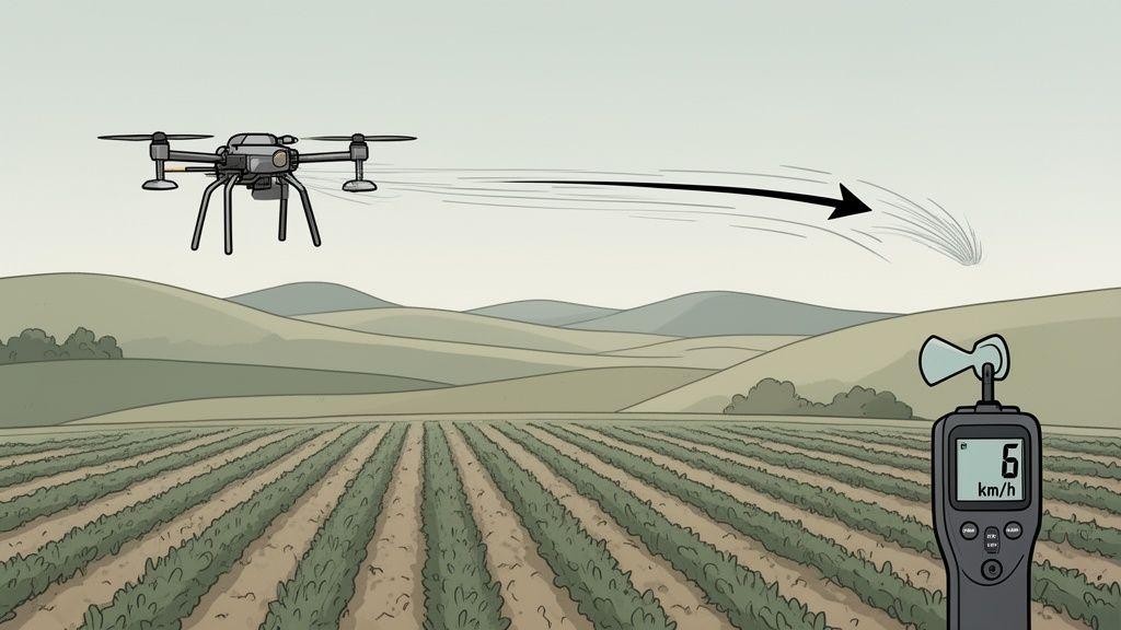
The provider surveys your field using GPS tools and pre-flight drone reconnaissance. They measure field boundaries, identify obstacles (power lines, trees, structures), map irrigation channels, and set GPS waypoints. Wind speeds above 15 mph trigger rescheduling. Field size determines battery and drone unit allocation for the mission.
Step 2: Drone Calibration and Route Programming
Sensors are calibrated for current light conditions and temperature. Flight paths are programmed into mission planning software using RTK (Real-Time Kinematic) base stations for centimetre-level GPS accuracy. If battery charge is below 80%, backup batteries are pre-assigned before launch.
Step 3: Flight Mission Execution
UAVs are launched to perform the programmed mission — mapping, spraying, or monitoring. The operator monitors live flight telemetry and adjusts for wind shifts in real time. For spraying missions, the system adjusts nozzle output based on flight speed and altitude to maintain consistent application rates.
Step 4: Data Analysis and NDVI Processing
After landing, captured imagery is processed through photogrammetry software to generate orthomosaic maps, NDVI heat maps, and elevation models. Thermal images are analysed for irrigation stress. Multispectral data is processed to identify pest hotspots and nutrient deficiencies.
Step 5: Reporting and Actionable Recommendations
The provider delivers a full report including annotated field maps, VRA (Variable Rate Application) spraying instructions, and crop health summaries with recommended interventions. Most providers deliver reports within 24–48 hours of the mission.
| 💡 Spray Efficiency Formula Spray Efficiency (Acres/Hour) = Drone Speed (mph) × Swath Width (ft) × Efficiency % ÷ 8.25 Example: Speed = 12 mph, Swath = 20 ft, Efficiency = 85% → Coverage ≈ 24.7 acres/hour — roughly 5× faster than conventional tractor spraying on comparable terrain. |
Equipment Used by Professional Drone Service Providers
The equipment a provider brings to your farm directly determines what data quality you receive and what terrain they can cover. Here is what the leading providers use in 2026:
| Drone Model | Payload | Flight Time | Primary Service Use |
| DJI Agras T50 | 50 kg | 25 min | Precision crop spraying — large acreage |
| DJI Phantom 5 RTK | 1.2 kg | 30 min | NDVI mapping, crop health monitoring |
| DJI Matrice 300 RTK | 2.7 kg | 55 min | Aerial imaging, livestock monitoring |
| DJI Matrice 350 RTK | 2.7 kg | 55 min | High-resolution farm mapping, surveying |
| Drone Spray Trailer | N/A | N/A | Field support / chemical resupply for spraying |
| 📌 Key Equipment Insight Spraying drones prioritise payload and chemical placement accuracy. Mapping UAVs prioritise sensor quality — the DJI Phantom 5 RTK captures at 2 cm per pixel, detecting micro-variations in crop health invisible to the human eye at ground level. |
Real Farm Case Study: 500-Acre Wheat Farm, Salina, Kansas
Challenge: A 500-acre wheat operation was seeing inconsistent yield across the field — some sections producing 15% below the farm average — with no clear explanation from ground-level scouting.
Solution: The farm hired a certified drone service provider to fly a combined NDVI mapping mission followed by a variable-rate spraying mission. Wind conditions averaged 12 mph during flight — within the provider’s operational limit.
Results After One Season
- Chemical savings: 12% reduction in total herbicide use ($1,800 season saving)
- Coverage speed: 60% faster than the farm’s previous conventional spraying method
- Yield improvement: 8% higher than the previous season’s tractor-sprayed result
- ROI: $2,500 net return in the first season after service costs
The NDVI maps identified three zones of phosphorus deficiency that ground scouting had missed entirely. Variable-rate fertiliser application targeted those zones only — no blanket application across the whole field.
For a detailed breakdown of the cost economics behind these savings, including how the per-acre service cost compares to the yield improvement value, see our full agricultural drone service cost breakdown and pricing per acre for 2026.
Pros and Cons of Hiring Agricultural Drone Services
| ✅ Pros | ❌ Cons |
| Rapid field coverage — 5–8 acres/hour | Service cost: $10–$25/acre per mission |
| Precise variable-rate chemical application | Weather-dependent — wind above 15 mph cancels flights |
| Real-time NDVI and thermal crop health data | Requires scheduling lead time with the provider |
| No soil compaction — suitable for wet and hilly terrain | Limited payload per flight — multiple batteries for large farms |
| FAA compliance handled by the provider | Data delivery takes 24–48 hours after the mission |
| Reduces labour by 60–75% vs manual scouting | Not all crops or field configurations suit drone application |
Before making a decision, use our full agricultural drone service pricing per acre guide to model the ROI for your specific farm size, crop type, and service frequency. It includes a worked example for a 300-acre mixed farm and a 1,000-acre grain operation.
Common Challenges and How Providers Solve Them
| Challenge | Root Cause | Provider Solution |
| Inaccurate mapping results | Poor GPS calibration or high wind | RTK base stations + flight rescheduling SOP |
| Spray drift onto neighbouring fields | Flying too high or in crosswind | 10 ft canopy height limit + wind monitoring |
| Sensor calibration errors | Firmware version mismatch | Pre-flight firmware check on every mission |
| Battery depletion mid-field | Underestimating field complexity | Backup battery allocation in mission planning |
| Regulatory non-compliance | Unlicensed operator | FAA Part 107 certified operators only |
The Future of Agricultural Drone Services (2026–2030)
Next-generation drone services are moving from reactive (fix a problem that already exists) to predictive (intervene before a problem develops). The key advances driving this shift:
- AI predictive analytics — models that flag yield risk 3–4 weeks before visible stress using weather + NDVI trend data
- Automated VRA routines — drones that adjust application rates mid-flight based on live sensor readings rather than pre-programmed maps
- Full integration with Precision Agriculture Technology systems — drone data feeding directly into farm management software for automated irrigation, fertiliser, and harvest scheduling
- Real-time crop stress alerts — push notifications to farm managers when NDVI thresholds drop below set intervention levels
- BVLOS (Beyond Visual Line of Sight) operations — FAA waiver expansion in 2026 allows larger autonomous coverage areas per mission
These advances position professional UAV services as essential infrastructure for competitive US farming — not a premium option but a standard operating tool for farms above 200 acres.
How to Find and Hire a Certified Agricultural Drone Service Provider
Hiring the wrong provider — one without FAA Part 107 certification or the right equipment for your crop type — is the most common and costly mistake farmers make when first using drone services. Here is exactly what to verify before signing any service agreement:
Non-Negotiable Verification Checklist
- FAA Part 107 Remote Pilot Certificate — ask to see the physical certificate or verify the certificate number at faa.gov/licenses_certificates
- Liability insurance — minimum $1M coverage for commercial drone operations; confirm it covers chemical drift for spraying missions
- Equipment specification match — confirm the drone they will use has the payload and sensor type your service requires (spraying vs NDVI vs thermal)
- Data deliverable format — confirm you receive the raw image files plus processed maps in a format compatible with your farm management software
- Cancellation and weather policy — how much notice do they give for wind/weather cancellations, and what is the rescheduling process?
For a complete breakdown of what each service type includes, what questions to ask at each provider type, and how pricing benchmarks vary by region, see our complete guide to agricultural drone services for US farmers.
Frequently Asked Questions
Q: What is the 2026 FAA drone weight limit for crop spraying?
A: Drones must comply with FAA Part 107 rules — typically under 55 lbs (25 kg) including payload for standard commercial operations. Heavier spraying drones require a Section 44807 exemption. Full certification requirements are explained in our guide to FAA regulations for agricultural drone operators in the USA.
Q: Can drone spraying really reduce chemical usage by 12%?
A: A: Yes — but the reduction depends on whether the provider uses NDVI-guided variable rate application (VRA). Blanket-rate drone spraying reduces usage only through better precision at the nozzle level (roughly 5–8%). NDVI-guided VRA eliminates application in low-stress zones entirely, driving the 10–15% reduction seen in 2026 field trials across Iowa and Kansas.
Q: How much do agricultural drone services cost per acre in 2026?
A: Costs vary significantly by service type — crop spraying typically runs $10–$25/acre, NDVI mapping runs $5–$15/acre, and combined spraying + mapping packages run $20–$35/acre. Our full pricing per acre guide breaks down every service type with regional benchmarks and a worked ROI example.
Q: Do I need a licence to hire a drone operator?
A: A: No — as the farm owner hiring the service, you do not need a licence. The operator must hold FAA Part 107 certification. You should verify their certificate number before any work begins.
Q: How long can a spraying drone operate before needing to recharge?
A: A: Most commercial spraying UAVs fly 20–30 minutes per battery charge at full payload. For a 500-acre farm, a single DJI Agras T50 with a rotation of backup batteries can complete a full spraying mission in 4–6 hours with a two-person crew.
Q: What is NDVI and why does it matter for crop spraying?
A: NDVI (Normalized Difference Vegetation Index) is a plant health score calculated from multispectral drone imagery. Scores range from -1 to +1 — healthy, dense crops score above 0.6; stressed or sparse areas score below 0.3. When applied before a spraying mission, NDVI maps tell the drone exactly which zones need treatment and at what rate — eliminating chemical waste in healthy areas. See our full guide to crop health monitoring with drones using NDVI for a complete explanation.
Q: Which crops benefit most from drone services?
A: A: In the US, the highest ROI applications are large-acreage row crops (corn, soybeans, wheat) for spraying efficiency, vineyards and orchards for precision treatment of difficult terrain, and cotton and rice for NDVI-guided variable rate fertiliser applications. Livestock operations above 500 acres see strong ROI from thermal monitoring services.
Summary: Is a Drone Service Right for Your Farm?
Agricultural drone services deliver measurable ROI for farms above 100 acres — particularly those spending heavily on labour, chemicals, or manual scouting. The key decision factors are:
- Farm size: above 100 acres, drone services typically break even versus traditional methods on cost alone. Above 300 acres, the ROI case is compelling.
- Crop type: row crops, orchards, and vineyards see the fastest payback. Vegetable farms and small mixed operations typically benefit more from a managed service than equipment ownership.
- Specific need: spraying, mapping, and monitoring serve different problems. Many farms start with one service type and expand once they see the data quality.
Ready to explore your options? Start by using our agricultural drone service pricing per acre guide to model the ROI for your farm size and crop type, then use the provider checklist above to evaluate specific operators in your region.