We know that the modern agriculture is rapidly evolving as farmers adopt new tools to improve productivity while managing costs and environmental impact. Traditional farming methods are still important, but many growers now combine them with digital technologies that provide better insights into crop health, soil conditions, and field performance.
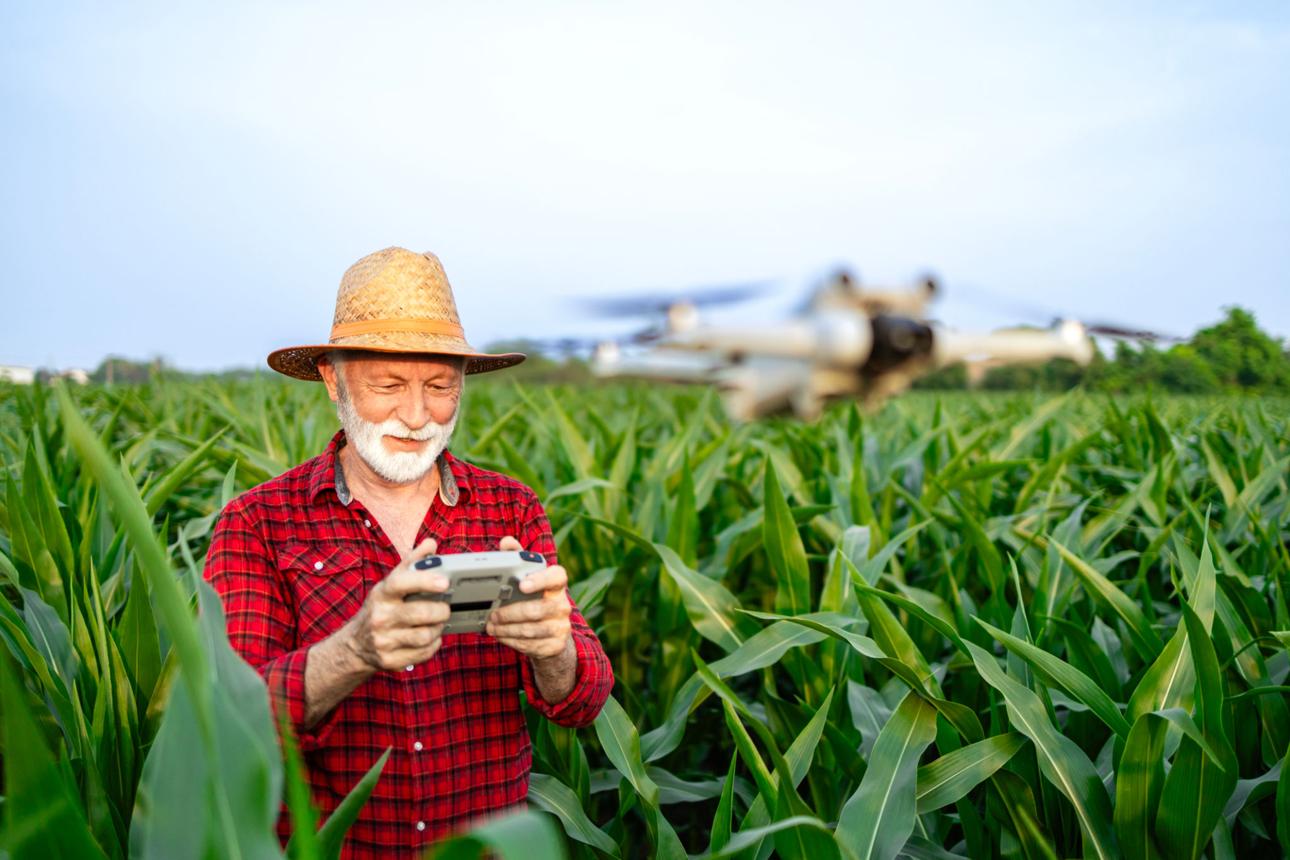
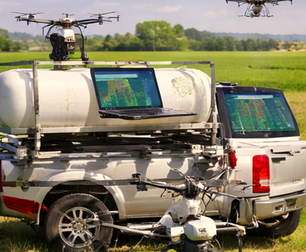
At our company, we work directly with growers by providing professional Agricultural Drone Services that support data-driven farming decisions. One of the most powerful innovations supporting this shift is Agricultural Drone Technology. These advanced aerial systems help farmers monitor crops, perform drone agriculture mapping, and apply treatments with high accuracy.
Across many regions, farms are increasingly using drones for agriculture to collect field data, perform crop scouting with drones, and support precision crop spraying operations. Instead of manually inspecting hundreds of acres, farmers can now use mapping drones and crop monitoring drones to analyze field conditions quickly and make informed decisions.
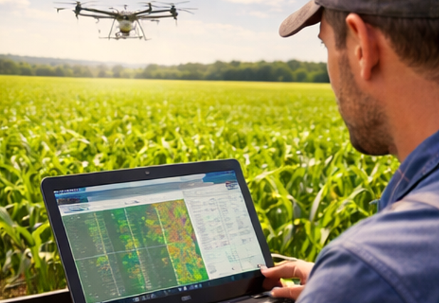
This approach supports modern Precision Agriculture strategies where every part of the field is managed based on real data rather than estimates. By combining aerial imaging, GPS automation, and farm analytics software, drones help growers increase efficiency while reducing wasted inputs.
How Agricultural Drone Technology Works
Agricultural drones are specialized unmanned aerial vehicles designed for farm operations such as crop monitoring, drone crop spraying, and aerial field mapping. These systems combine flight automation, imaging sensors, and data processing tools to support precision farming.
GPS Flight Automation
Modern farm drones rely on GPS-based flight automation to perform accurate missions across agricultural fields. Operators use mission planning software to define the field boundaries and flight routes before launching the drone.
Once airborne, the drone follows a programmed path while capturing aerial imagery or applying crop treatments. Advanced positioning technologies such as RTK improve drone survey accuracy and allow drones to fly consistent patterns across large fields.
This automated system allows mapping drones to collect high-resolution imagery while ensuring complete coverage of the farm area.
Crop Monitoring Sensors
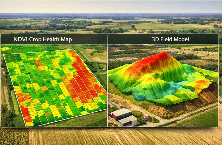
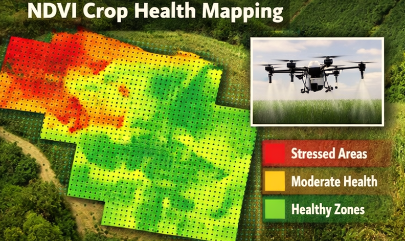
Many agricultural drones carry advanced imaging sensors designed for crop health monitoring. A multispectral drone captures light across different wavelengths, allowing farmers to detect plant stress before visible damage appears.
Multispectral imaging drones generate vegetation maps that highlight problem areas such as nutrient deficiencies, pest damage, or irrigation issues. Farmers can then target those areas with precise treatments.
Technologies such as the DJI Mavic 3 multispectral drone are widely used for crop health monitoring drones and drone assisted crop monitoring operations.
Precision Spraying Systems
Drone sprayers allow farmers to apply pesticides, fertilizers, and herbicides with greater control than traditional equipment. A modern agriculture spray drone includes smart nozzles that adjust the spray pattern based on altitude and speed.
These systems are commonly used by providers offering Crop Spraying Drone Services to farms. Spraying drones can reach steep terrain, wet fields, and other areas where traditional machinery struggles to operate.
By using drones for spraying crops, farmers can apply chemicals more efficiently and reduce unnecessary chemical usage.
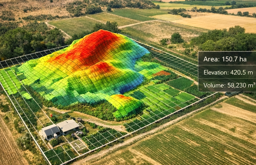
Aerial Mapping Tools
Aerial mapping drones collect hundreds of high-resolution images during a single flight mission. Specialized drone mapping software processes these images using photogrammetry to create detailed field maps.
Farmers use drone mapping for agriculture to analyze plant growth patterns, soil conditions, and drainage systems. These maps are also valuable for drone contour mapping and drone land mapping used in farm planning.
Many growers rely on professional Drone Mapping Services to create accurate aerial maps and agricultural analysis reports.
Types of Agricultural Drones
Agricultural drones are designed for different farming operations. Each type of drone serves a specific role within precision farming systems.
Crop Spraying Drones
Crop spraying drones are built to apply fertilizers, pesticides, and herbicides across agricultural fields. These spray drones carry tanks and precision nozzles designed to distribute liquids evenly across crops.
Modern models such as the DJI Agras T50 agricultural drone and DJI Agras T40 spray drone are widely used for drone spraying crops and agricultural spraying drone operations.
These drones allow farmers to treat large areas efficiently while reducing chemical waste.
Aerial Mapping Drones
Mapping drones are designed to collect aerial images used for agricultural field analysis. These drones carry high-resolution cameras or multispectral imaging sensors.
Farmers use mapping drones for drone farm mapping, drone site mapping, and drone contour mapping. These aerial surveys help growers monitor crop growth and plan field operations more effectively.
Multispectral Imaging Drones
Multispectral imaging drones capture data used for advanced crop monitoring and precision agriculture analysis.
A multispectral drone camera measures plant reflectance patterns that reveal plant health conditions. These insights help farmers detect early crop stress and adjust irrigation or fertilizer strategies.
Real Farming Applications
Agricultural drones are now used in many practical farming situations. These applications help growers improve productivity while managing resources more efficiently.
Early Crop Disease Detection
Crop diseases often spread before visible symptoms appear. Multispectral imaging drones can detect early signs of plant stress through vegetation analysis.
By identifying these patterns early, farmers can apply targeted treatments and prevent large-scale crop damage.
Targeted Pest Management
Traditional pesticide spraying often treats entire fields. Drone crop spraying allows farmers to treat only specific areas where pests or weeds are present.
This approach reduces chemical usage and lowers input costs while maintaining crop protection.
Improved Irrigation Planning
Drone aerial mapping helps farmers identify drainage problems, soil moisture variations, and uneven field elevations.
By analyzing drone land mapping data, farmers can improve irrigation planning and distribute water more efficiently across fields.
Benefits for Farmers
Agricultural drones provide several advantages for modern farming operations.
Faster Crop Monitoring
Using crop monitoring drones allows farmers to inspect large farms in a fraction of the time required for manual field scouting.
Better Data for Farm Decisions
Drone mapping and crop analysis provide farmers with detailed insights about crop growth, soil conditions, and irrigation patterns.
Efficient Chemical Application
Drone spraying systems allow precise pesticide and fertilizer application, reducing chemical waste and improving crop protection.
Reduced Labor Requirements
Drone operations require fewer workers compared to traditional crop inspection and spraying methods.
Limitations and Challenges
Despite their benefits, agricultural drones also present some practical challenges.
Weather Conditions
Drone flights depend on favorable weather conditions. Strong winds or rain may delay aerial surveys or spraying operations.
Battery Life
Most agriculture drones operate for approximately 20 to 40 minutes per battery. Large farms may require multiple flights to complete a full survey.
Training and Certification
Operating drones safely requires training and compliance with aviation regulations. Many farms prefer hiring professional drone service providers instead of managing equipment themselves.
Costs and Efficiency
Adopting agricultural drones involves several cost considerations. Purchasing large agricultural drones, mapping sensors, and drone mapping software can require a significant investment.
For many farms, hiring professional providers offering Agricultural Drone Services is a practical solution. Service providers already have the equipment, trained pilots, and analysis software required for complex drone missions.
Drone technology helps farms reduce costs by:
- lowering pesticide and fertilizer usage
- improving yield monitoring through drone mapping
- reducing manual field scouting labor
- improving crop management efficiency
Over time, these efficiency improvements help farms increase profitability while using resources more responsibly.
Future of Agricultural Drone Technology
Agricultural drones continue to evolve as new technologies are introduced into farming systems.
Artificial intelligence is now being integrated into drone analysis platforms. AI algorithms can analyze aerial images to detect crop disease, pest damage, and nutrient deficiencies automatically.
Automated drone fleets are another emerging trend. Instead of flying a single drone, farms may soon deploy multiple coordinated drones that perform mapping and crop monitoring missions simultaneously.
Drone data is also becoming integrated with farm management software, satellite imagery, and soil sensors. This creates a complete digital ecosystem that supports precision agriculture and data-driven farm management.
As these technologies continue to develop, drones will play an even larger role in modern agriculture.
How Farmers Can Find Reliable Drone Services
Many farmers prefer working with professional drone operators rather than purchasing equipment themselves. Experienced operators provide specialized drones, certified pilots, and advanced agricultural mapping tools.
Our company helps growers connect with trusted providers through our directory of verified drone operators. Farmers can easily locate companies that provide mapping, monitoring, and spraying services in their region.
By using experienced service providers, farmers gain access to modern drone technology without needing to invest in expensive equipment or training.
Frequently Asked Questions
How accurate are agricultural drones
Modern agricultural drones equipped with RTK positioning systems can achieve centimeter-level accuracy. This level of precision is important for tasks such as drone mapping for agriculture and targeted crop spraying.
Are drone spraying services expensive
Drone spraying services are often competitive with traditional crop spraying methods. Because drones apply chemicals precisely, farmers frequently reduce pesticide usage and lower overall treatment costs.
Can drones detect crop diseases
Yes. Multispectral imaging drones can detect plant stress patterns before visible symptoms appear. Early detection allows farmers to respond quickly and protect crop yields.
Do farmers need licenses to operate drones
In the United States, commercial drone operations must follow FAA regulations. Many farmers work with licensed drone service providers who manage regulatory compliance.
How large of a farm can a drone cover
Coverage depends on the drone model and mission type. High-capacity agricultural spray drones and mapping drones can monitor or treat hundreds of acres per day with multiple flight missions.
Leave a Reply